- 翰林提供学术活动、国际课程、科研项目一站式留学背景提升服务!
- 400 888 0080
2019年1月19日雅思写作真题解析(上)

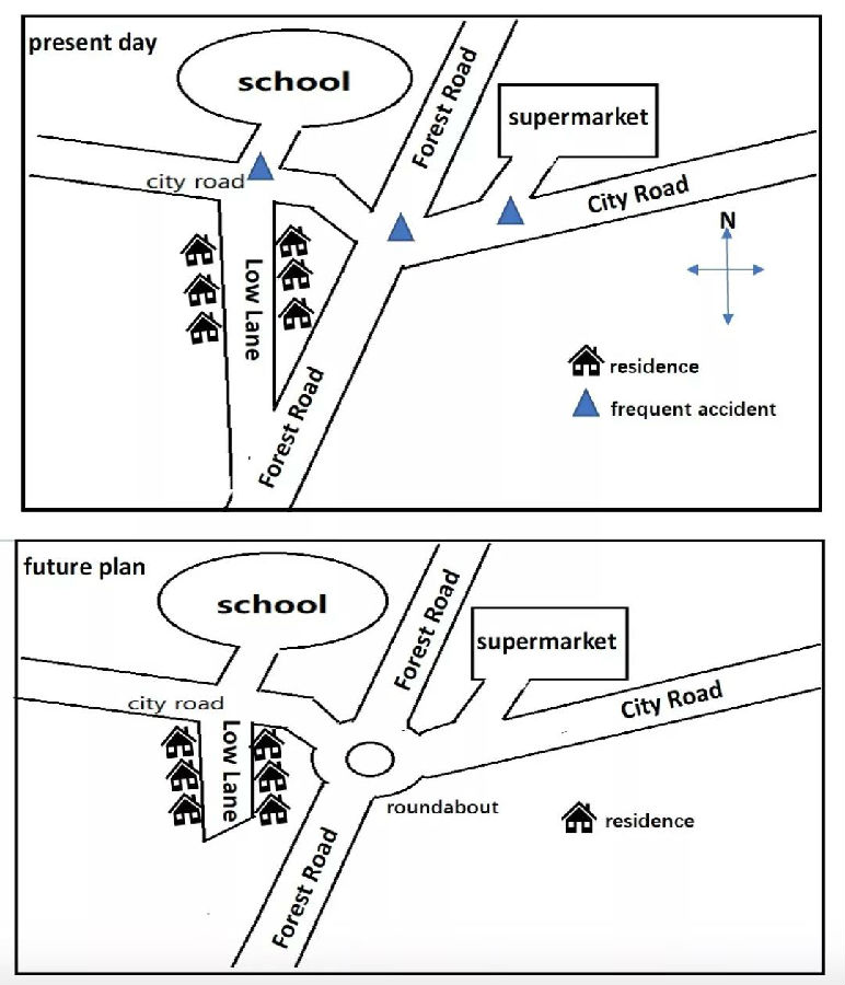
题目:The maps show the proposed change of a particular fields in order to reduce the traffic accidents in the UK.
类型:地图题/历史变迁
考点/写作要点:
1. 时态:描述图一使用一般现在时,描述图二选择将来时(future plan);
2. 注意分段:introduction, (frequent accidents), 描述图一,描述图二,
3. 在描述图一时要注意方位词的使用,以及方位顺序,可以按照由北到南,由东到西的顺序;
4. 对于每一个细节都要照顾到,不能忽略几条道路的描述,residence以及常发生意外的地点;
5. 描述图二时,要注意Low Lane不再和Forrest Road相交;
6. 描述两条道路相交可以使用的词为intersect / conjunct with.
注意使用there be句型。
范文:
The two maps illustrate what construction will be carried out in an England residential area for the purpose of reducing possibility of traffic accidents.
As shown in the first map, the frequent accidents usually take place in three spots: the first one is on the west of the City Road, just in front of the school. The second one is at the spot where Forrest Road intersects with the City Road. And the third one is at a small pathway, in conjunction with the east side of City Road.
At present, from the north to the south is the main road Forrest Road, it is in conjunction with the City Road which extends from the west to the east. The west side of the City Road leads to the school, and it is located in the north-west of the residential area. The Low Lane directs to the living district, which sits in the west to the Forrest Road. The lane is in conjunction with both the City Road and the Forrest road. The supermarket is situated to the east of the Forrest Road, residents can get groceries there by driving along the City Road.
In the future, it is noticeable that a roundabout will be built in the centre of the Forrest Road, which might reduce the speed of the vehicles. Another noticeable change is that the south side of the Low Lane will no longer be connected to the Forrest Road. For those residents living in this district wishing to go to the main road, the only way will be driving back to the City Road and passing the roundabout.

最新发布
© 2025. All Rights Reserved. 沪ICP备2023009024号-1


